Clare WalkClare Walk is an easy 3.5 mile circular walk in the countryside around Clare using the Country Park as your gateway. The park is open every day for visitors and car parking and admission is free! The route is clearly marked with green public footpath signs and yellow waymark arrows displaying a circular walk symbol enabling you to walk in either direction. It should take you around two hours to complete, but short cuts can be made by returning along the rideside footways crossed by the walk. Stout, waterproof footwear should be worn except in especially dry conditions. The following Ordnance Survey sheet would be useful to find other rights-of-way in the area: Pathfinder Series sheet 1028TL 64/74 Haverhill. Or click on the following maps supplied by the Ordnance Survey: 1:250,000 OS Map of Clare
1:50,000 OS Map of Clare | 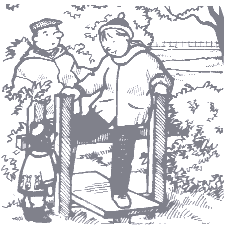 |
 In the park, shorter walks are provided on a History Trail or a Nature Trail theme, taking you along the riverside and woodland paths. In the park, shorter walks are provided on a History Trail or a Nature Trail theme, taking you along the riverside and woodland paths.
There are also picnic areas, a childrens adventure playground, a butterfly garden, wildlife ponds, visitor centre and toilets. Refreshments may be obtained from one of the many public houses in the town as well as from shops or the sandwich delicatessen. The Walk 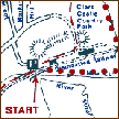 | Click for
Route Map |
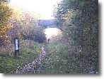
Leave the Country Park to the north following the circular walk signs, cross the Cavendish Road to Eastfield Farm Lane. The playing field on the left once provided grazing for livestock from the castle, watered by the Chiltern Stream. Keeping to the right, Harps Lane emerges at a stile leading to a field edge path. From Hermitage Farm follow the drive to Bridewell Street. Sheepgate Lane skirts the edge of Clare Camp, formerly known as Erbury, meaning earth fortification. This is an interesting area to explore, it has been suggested that it was an Iron Age hill fort and also the Romans once used the site (Clare may also be a Roman name - Clarus, meaning renowned). From the path around the Upper Common a good view of the town can be had, including the castle ruins above the treeline. Although now cultivated, the Upper Common gave common pasture to the poorer people of the town and is still managed by the Charities Committee. After passing the entrance to the cemetery, the walk is routed around a field with walls on two sides. This forms part of the old town wall and was probably built using materials from the ruined castle. Emerging onto Nethergate Street, turn left and cross into Ashen Road. This leads to a well preserved white cast-iron bridge, spanning the New Cut and displays the date 1813 on it's centre arch. The railway also crossed the road at this point and the old brickwork of this crossing is still visible. Follow the path between the river and the dismantled railway (the station and it's platforms still survive), crossing into the Country Park via the surviving railway bridge. | 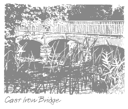 |
This bridge was last used by rolling stock in 1967 when the railway was closed. You can then enjoy an informative visit to the Park Centre, which houses an exhibition about the castle and the old railway (an original railway goods wagon is displayed on tracks in the centre).  | FURTHER INFORMATION
If you would like details of other countryside walks and rides in Suffolk, please contact:
The County Council Planning Department, St Edmund House, County Hall, Ipswich, Suffolk, IP4 1LZ
Tel: 01473 265131 or click this tourism link. | | Remember to always follow the Country Code |
|
